About NC360

Inspired by the 100th anniversary of North Carolina state parks in 2016, the N.C. Department of Information Technology set out to find a way to use technology to highlight these natural resources and make them more accessible to those unable to visit them easily.
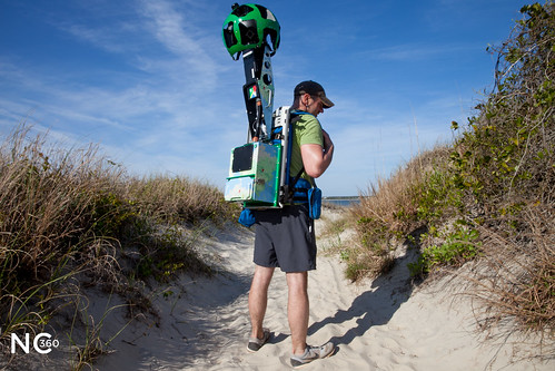
The iCenter partnered with Google to participate in the Street View Trekker program. With a Street View camera mounted on a hiking pack, a team of DIT and state parks employees traveled the state over several months to capture 360-degree imagery of 30 sites. The imagery was then added to Google Street View.
In 2018, the Trekker returned to North Carolina to kick off the project’s second phase. A team of DIT employees captured imagery of 20 cultural and historic sites, as well as parks. The project was also expanded with 360-degree imagery, including indoors, from other cameras.
The project will continue to grow and evolve as a way to provide immersive, virtual access to all North Carolina has to offer.
Miles Trekked
Parks
Historic & Cultural Sites
NC 360 Behind the Scenes
Hover over the photo to scroll through the photos on Flickr.
Hear from the Trekkers
Frequently Asked Questions
The NC360 project is an imagery initiative with the goal of providing an immersive experience of the natural and cultural sites in North Carolina. The project includes 360-degree imagery from the Google Street View Trekker available on Google Street View, as well as indoor imagery from other 360-degree cameras.
The NC360 project was a joint effort between several groups in the N.C. Department of Information Technology, with assistance from personnel from the N.C. Department of Natural and Cultural Resources and interns from N.C. State University's College of Natural Resources. The project was launched in 2016.
NCDIT staff and personnel from the Department of Natural and Cultural Resources coordinated with the parks and captured imagery from 30 trails with the Google Street View Trekker during the first phase of the project.
During the second phase in 2018, NCDIT employed interns from N.C. State's College of Natural Resources to help capture imagery of 20 additional sites with the Google Street View Trekker.
NCDIT's NCDIT Digital Solutions team and communications office collaborated to document the process and create a website making all of the imagery available.
The NC360 project began in late 2016, with imagery collection taking place between 2016 and 2018.
To date, 50 sites, including 30 parks and 20 attractions, across the state have been captured with the Google Street View Trekker. Several more sites have been photographed with other 360-degree cameras that allow for indoor imagery.
The imagery spans the breadth of North Carolina from the mountains to the coast. See a full list of NC360 project sites.
Often, IT is seen as an administrative function in the workplace, but it can be much more. This project demonstrates how technology can directly add value to citizens.